How Satellites Enable New Zealand's Land Transport Sector
New Zealand’s rugged landscapes, spanning mountains, rivers, and vast rural areas, present significant challenges for the land transport sector. Efficient and safe transportation is crucial for a country that relies heavily on its road and rail networks to connect communities, facilitate trade, and promote tourism. Satellites have emerged as indispensable tools for overcoming these challenges, enabling advanced navigation, real-time communication, logistics optimisation, and infrastructure management.
In this article, we will explore the various ways satellites support New Zealand’s land transport sector, highlighting their impact on safety, efficiency, and innovation.
Satellite Navigation: Transforming Travel and Logistics
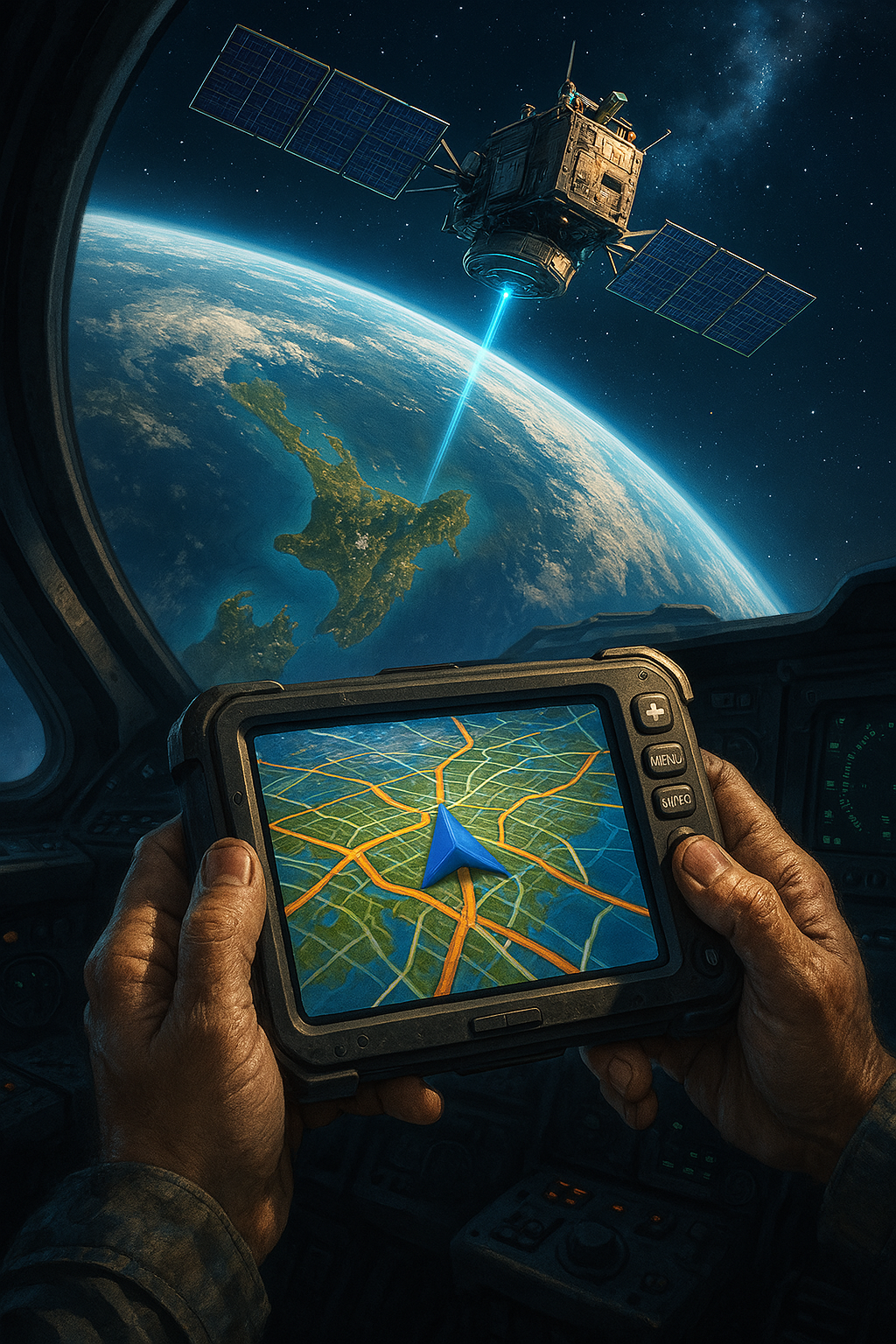
Global Navigation Satellite Systems (GNSS) are the cornerstone of satellite-enabled land transport. GNSS constellations, such as the United States’ GPS, Europe’s Galileo, and China’s BeiDou, provide precise positioning and timing data that power navigation and logistics systems across New Zealand.
Navigation for Personal and Commercial Vehicles
Satellite navigation has become essential for drivers, enabling efficient route planning, avoiding traffic congestion, and finding alternative paths in real-time. Apps like Google Maps and Waze rely on GNSS data to provide turn-by-turn directions and traffic updates.
Personal Travel: For everyday commuters and tourists navigating unfamiliar routes, satellite-enabled navigation ensures smoother and safer journeys.
Commercial Transport: Fleet operators use GNSS to optimise delivery routes, monitor vehicle locations, and minimise fuel consumption, reducing costs and environmental impact.
Precision in Rail Operations
In New Zealand’s rail sector, GNSS is utilized for train tracking and management, thereby enhancing operational efficiency and passenger safety. Satellite navigation facilitates the precise location of trains, enabling more accurate scheduling and reducing the risk of collisions.
Enhancing Safety with Real-Time Monitoring
Safety is paramount in land transport, and satellites play a critical role in ensuring the well-being of drivers, passengers, and cargo.
Accident Prevention
Satellite-enabled Advanced Driver Assistance Systems (ADAS) utilise GNSS data to alert drivers to potential hazards, such as sharp curves, speed limits, or upcoming intersections. These systems reduce human error, a leading cause of road accidents.
Emergency Response
In the event of an accident, satellite systems can automatically alert emergency services to the precise location of the incident. For example, eCall systems in vehicles use GNSS data to send distress signals, expediting response times and potentially saving lives.
Real-Time Monitoring for Fleet Management
Commercial fleet operators in New Zealand leverage satellite tracking to monitor driver behaviour, vehicle conditions, and cargo status. By identifying unsafe practices or mechanical issues, companies can proactively address risks, ensuring safer operations.
Enabling Intelligent Transportation Systems (ITS)
Intelligent Transportation Systems (ITS) integrate satellite technology with infrastructure and communication networks to improve transport efficiency and reduce congestion.
Traffic Management
Satellites provide the data required for real-time traffic monitoring, enabling authorities to manage congestion effectively. For instance, satellite imagery can identify traffic patterns, accidents, or roadblocks, allowing swift action to redirect traffic or deploy resources.
Dynamic Tolling and Parking Management
GNSS technology supports dynamic tolling systems, where fees are calculated based on the distance travelled or congestion levels. In urban areas, satellite data is also used to guide drivers to available parking spaces, reducing time spent searching and easing traffic flow.

Supporting Infrastructure Maintenance and Development
New Zealand’s diverse terrain demands a robust and well-maintained transport infrastructure. Satellites provide the tools needed to monitor and manage roads, bridges, and railways effectively.
Remote Sensing for Infrastructure Monitoring
Earth observation satellites equipped with high-resolution cameras and sensors monitor the condition of transport infrastructure. For example:
Bridge Stability: Satellites detect minute shifts or stresses in bridges, allowing authorities to address structural issues before they become critical.
Road Surface Monitoring: Satellite imagery identifies wear and tear on road surfaces, guiding maintenance efforts and prioritising repairs.
Planning and Construction
Satellite data aids in the planning and construction of new transport infrastructure by providing accurate topographical maps and environmental impact assessments. This ensures projects are executed efficiently and sustainably..
Improving Logistics and Supply Chain Efficiency
The land transport sector is vital for New Zealand’s supply chain, connecting ports, warehouses, and retail hubs. Satellites enable streamlined logistics, reducing costs and enhancing reliability.
Fleet Optimization
GNSS-based tracking systems allow logistics companies to monitor vehicle movements and optimise delivery schedules. By minimising idle time and ensuring the most efficient routes, businesses can reduce fuel consumption and delivery times.
Cold Chain Management
For industries like agriculture and healthcare, which rely on temperature-sensitive goods, satellites enable real-time monitoring of cargo conditions. Satellite-connected sensors track temperature, humidity, and location, ensuring goods remain within safe parameters during transit.

Preparing for Future Transport Innovations
Satellites are paving the way for next-generation transport technologies that will transform New Zealand’s land transport sector.
Autonomous Vehicles
Self-driving cars and trucks rely on GNSS for precise positioning and navigation. Satellites provide the high-accuracy data required for autonomous vehicles to operate safely and efficiently on New Zealand’s roads.
Connected Vehicle Ecosystems
Satellites enable Vehicle-to-Everything (V2X) communication, where vehicles exchange data with one another and with the surrounding infrastructure. This technology improves traffic flow, enhances safety, and supports the adoption of innovative city initiatives.
Conclusion
Satellites are the unsung heroes of New Zealand’s land transport sector, driving innovation, safety, and efficiency across the country. From enabling precise navigation to supporting intelligent transportation systems and infrastructure management, satellite technology is integral to meeting the challenges posed by New Zealand’s unique geography and growing transport demands.
As advancements in satellite technology continue, the land transport sector will benefit from even greater connectivity, sustainability, and resilience, ensuring New Zealand remains a leader in leveraging space technology for terrestrial success. The partnership between space and land transport will undoubtedly shape the future of mobility in New Zealand, creating a safer, more innovative, and more sustainable transportation ecosystem.